


Down by the toe of Louisiana’s boot, Bayou Grand Liard used to be surrounded by solid land.
“I’ve talked to people whose fathers and grandfathers used to come out here and hunt rabbits. Now you see it’s all open water,” says Chuck Perrodin, a spokesman for the Coastal Protection and Restoration Authority.
To fix that, the CPRA is in the middle of a marsh creation project at Bayou Grand Liard. “We’re taking what used to be land and marsh, went back into open water, now we have made it back into land,” Perrodin says.
Creating land where there’s open water seems like an impossible task, but the basic idea is relatively simple: get a bunch of sand and pile it in the water. Finding and transporting that sand is the hard part.
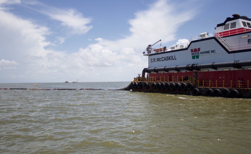
The C.R. McCaskill sits an hour offshore in the Gulf of Mexico, near Scofield Island. The McCaskill is a giant, rectangular dredge boat. Its bridge looks like that of the Starship Enterprise: computer screens surround the captain’s chair flashing vital data. In front of the bridge’s viewport, cables and a large pipe reach down to the gulf bottom 35-feet below.

The McCaskill mines the sand that becomes the base of the new marsh. “In front of us and reaching down to the gulf shore is what we call a cutter head,” Perrodin explains. “It’s kind of like a pine cone, a big, strong, metal pine cone that churns and turns up the sand and sediment at the bottom of the gulf.” That sediment is then sucked into a pipeline that winds its way for nine miles back onshore to Bayou Grand Liard.
Small, earthen dikes divide the marsh creation site into containment pens. Once those dikes are built, “We pump in sediment and build up the land so the marsh can grow,” says Perrodin. Filling in these containment pens isn’t the end of the project, though.
Kimberly Clements works for the National Oceanic and Atmospheric Administration, which is the federal sponsor for this project. “This is like the heavy lifting, you know like the first level of construction, you’re pumping the material in,” she says, “and we’ll come back and start vegetative plantings to kick start the ecological functions of the site.” According to Clements, this is a Coastal Wetlands Planning, Protection and Restoration Act project that costs $44 million.
These restoration projects have a strategy to them. CPRA doesn’t just go around creating marsh willy-nilly. Before the Bayou Grand Liard project, the state built a sort of perimeter system out of the barrier island chain along Louisiana’s coast. “The reconstruction of out barrier islands—phenomenal,” Perrodin says. “They had wasted away to nothing. Now they’re big and beefy and substantial. This is really, really important in establishing the perimeter.”
Having that buffer is key to preventing waves and hurricanes from destroying the relatively fragile interior marsh. “We built protection, but the ecosystem is actually protection for the protection,” Perrodin says.
And we need all the protection we can get. Louisiana loses, on average, a football field of wetlands every 45 minutes. But Perrodin says CPRA is doing everything they can to combat that. Over the past seven years, CPRA has created more than 34,000 football fields of land in coastal Louisiana. This project will contribute another 660. But to protect the entire coast, that’s not enough.
“That is a marvelous—and very expensive way—of creating hundreds of acres of land,” Perrodin says. “But the basin—we need hundreds and thousands of square miles of land and that’s going to take more than dredges and pipes.”
To create that much land, the state wants to build sediment diversions. Sediment from the Mississippi River created much of south Louisiana over a period of thousands of years. Sediment diversions mimic that land building process on smaller scales.
But a decision on whether or not to move forward with sediment diversions won’t be made until the Mississippi River Hydrodynamic and Delta Modelling Study is completed at the end of this year.